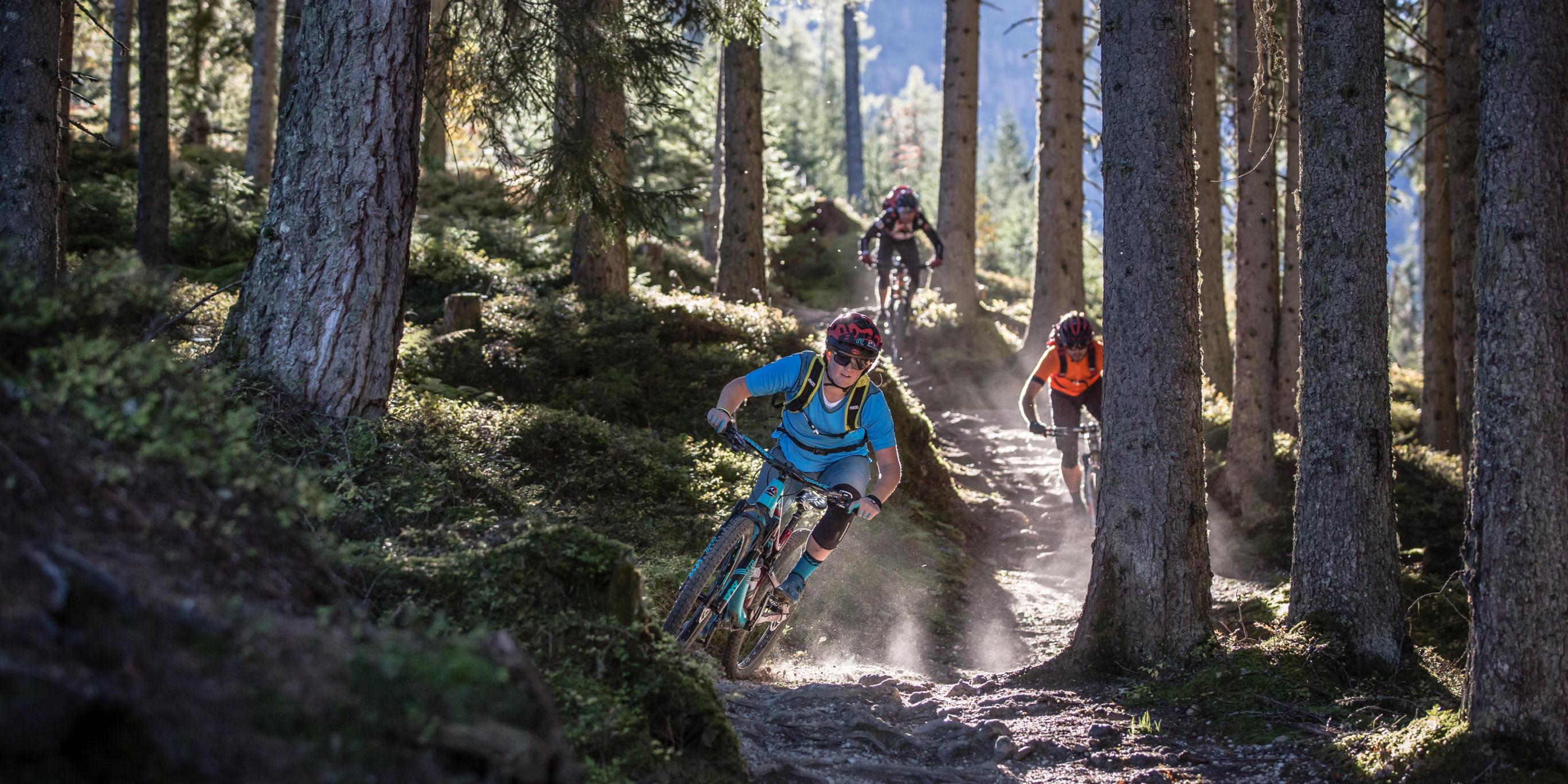
147 kilometres of pure mountain bike emotion. Experience a once-in-a-lifetime experience at the Stoneman Taurista.
As always: You choose your starting point yourself – just as it suits you best. You can also choose the date of your ride within the season completely free.
Stages for your bronze tour (3 days)
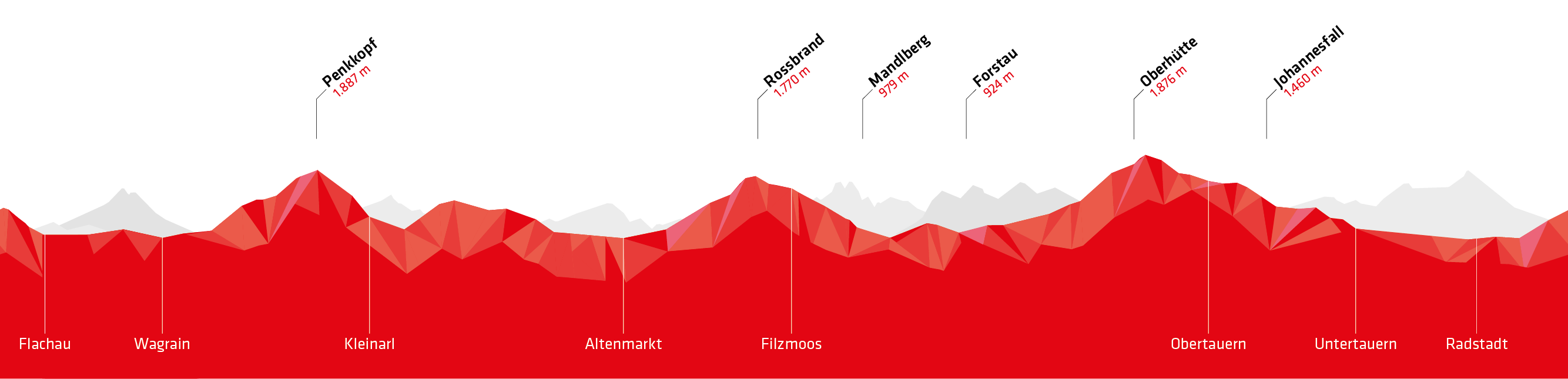
Tag 1
Flachau » Flachau
- 51 km
- 1.600 Hm
-
-
Checkpoints:
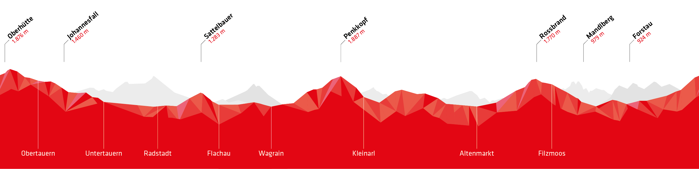
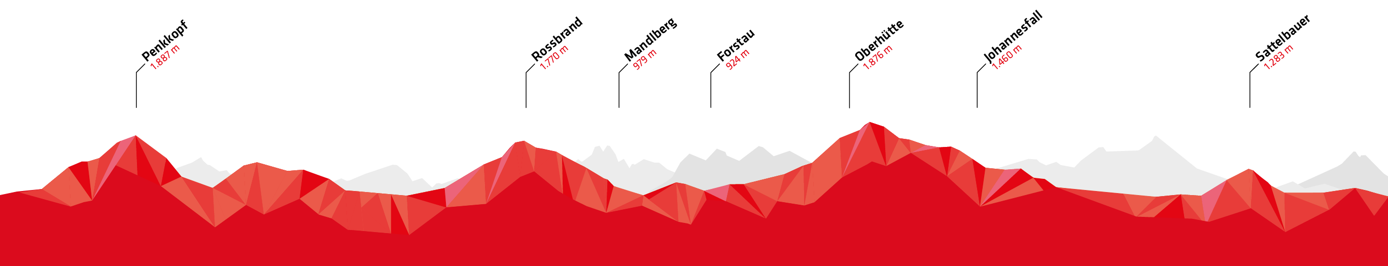
- Penkkopf
Tag 2
Altenmarkt » Flachau
- 36 km
- 1.420 Hm
-
-
Checkpoints:
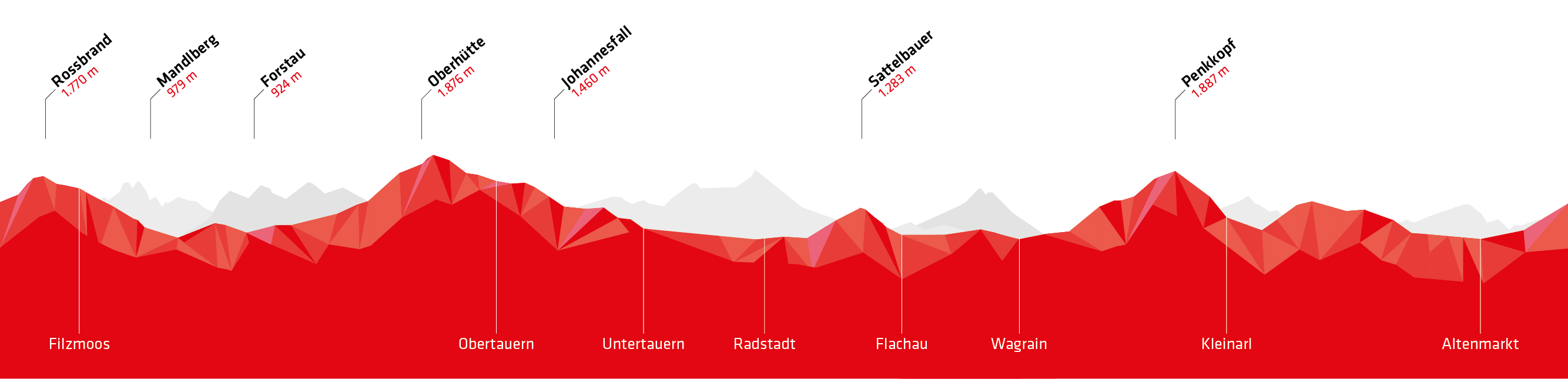
- Rossbrand
- Mandlberggut
- Sattelbauer
- Access route in the morning: cycling path Flachau—Altenmarkt
- 5 km
- 90 meters in altitude
- Enns cycling path Mandling—Altenmarkt. Start off fresh here with Checkpoint Sattelbauer as next milestone
- 13 km
- 70 meters in altitude
Tag 3
Mandling » Altenmarkt
- 60 km
- 1.680 Hm
-
-
Checkpoints:
- Forstau
- Oberhütte
- Johanneswasserfall
- Access route in the morning: Enns cycling path Flachau—Mandling
- 20 km
- 10 meters in altitude
- Return in the evening: Enns cycling path Altenmarkt—Flachau
- 7 km
- 70 meters in altitude
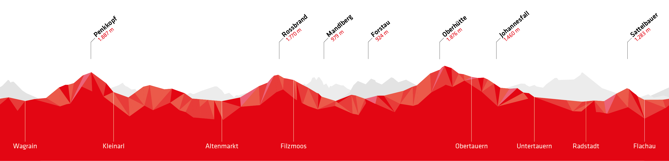
Tag 1
Wagrain » Wagrain
- 37 km
- 1.500 Hm
-
-
Checkpoints:
- Penkkopf
- Return in the evening Wagrain-Moardörfl to Wagrain
- 5 km
- 170 meters in altitude
Tag 2
Altenmarkt » Mandling
- 45 km
- 1.480 Hm
-
-
Checkpoints:
- Rossbrand
- Mandlberggut
- Sattelbauer
- Transfer in the morning from Wagrain Moardörfl to Wagrain, transfer from Mandling-Altenmarkt, return in the evening remains the same
- 5 km
- 170 meters in altitude
- Return in the evening: cycling path Flachau—Wagrain
- 5 km
- 170 meters in altitude
Tag 3
Mandling » Altenmarkt
- 65 km
- 1.720 Hm
-
-
Checkpoints:
- Forstau
- Oberhütte
- Johanneswasserfall
- Access in the morning: cycling path to Flachau, continue on Enns cycling path to Mandling
- Return in the evening: Enns cycling path from Altenmarkt to continue on the cycle path to Wagrain
- 12 km
- 100 meters in altitude
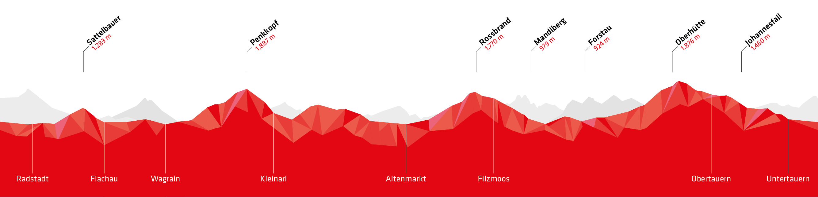
Tag 1
Radstadt » Flachau
- 54 km
- 1.600 Hm
-
-
Checkpoints:
- Penkkopf
- Transfer in the morning and return in the evening Radstadt-Flachau
- 8 km
- 15 meters in altitude
Tag 2
Altenmarkt » Flachau
- 33 km
- 1.350 Hm
-
-
Checkpoints:
- Sattelbauer
- Rossbrand
- Mandlberggut
- Access in the morning: Enns cycle path Radstadt—Altenmarkt
- 5 km
- 15 meters in altitude
- Transfer from Flachau to Altenmarkt
- 6 km
- 70 meters in altitude
Tag 3
Mandling » Radstadt
- 60 km
- 1.750 Hm
-
-
Checkpoints:
- Forstau
- Oberhütte
- Johanneswasserfall
- Access in the morning: train at 8:09 from Radstadt to Mandling, or ride on the Enns cycle path Radstadt—Mandling
- 4 km
- 20 meters in altitude
- Return in the evening: ride from Höggen to Radstadt
- 2 km
- 20 meters in altitude
Tag 1
Altenmarkt » Altenmarkt
- 54 km
- 1.600 Hm
-
-
Checkpoints:
- Penkkopf
- Transfer in the morning and in the evening via Enns cycle path Altenmarkt-Flachau
- 5 km
- 10 meters in altitude
Tag 2
Altenmarkt » Mandling
- 33 km
- 1.350 Hm
-
-
Checkpoints:
- Sattelbauer
- Rossbrand
- Mandlberggut
- Transfer from Flachau to Altenmarkt
- 4 km
- Return in the evening from Mandling to Altenmarkt
- 14 km
Tag 3
Mandling » Altenmarkt
- 60 km
- 1.750 Hm
-
-
Checkpoints:
- Forstau
- Oberhütte
- Johanneswasserfall
- Transfer in the morning from Altenmarkt to Mandling
- 14 km
Tag 1
Obertauern » Mandling
- 63 km
- 1.550 Hm
-
-
Checkpoints:
- Johanneswasserfall
- Sattelbauer
- Rossbrand
- Mandlberggut
- Return from Mandling to Obertauern via bike or taxi.
Tag 2
Obertauern » Flachau
- 54 km
- 1.600 Hm
-
-
Checkpoints:
- Penkkopf
- Transfer in the morning from Obertauern to Flachau
Tag 3
Mandling » Obertauern
- 30 km
- 1.550 Hm
-
-
Checkpoints:
- Forstau
- Oberhütte
- Access to route in the morning: Ride oder take a cab from Obertauern—Mandling or take the bus to Radstadt and continue on the Enns cycling path to Mandling
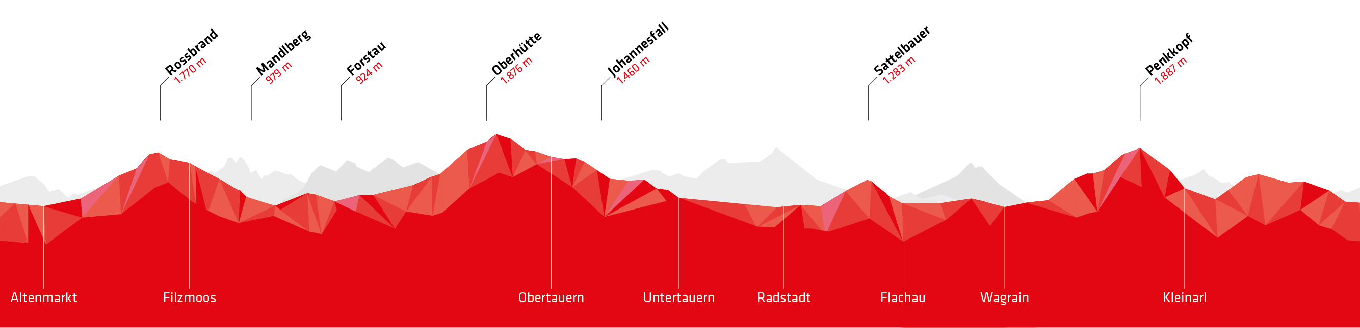
Tag 1
Filzmoos » Radstadt
- 57 km
- 1.560 Hm
-
-
Checkpoints:
- Mandlberggut
- Forstau
- Oberhütte
- Johanneswasserfall
- Access in the morning: from the parking lot opposite the gas station – towards Ramsau – follow the cycle path Rossbrand SW 01
- 4,4 km
- 175 meters in altitude
- Transfer in the evening Radstadt–Filzmoos
Tag 2
Flachau » Flachau
- 54 km
- 1.600 Hm
-
-
Checkpoints:
- Penkkopf
- Transfer Filzmoos–Flachau and return in the evening
- 18 km
Tag 3
Altenmarkt » Filzmoos
- 36 km
- 1.540 Hm
-
-
Checkpoints:
- Sattelbauer
- Rossbrand
- Access in the morning: from Filzmoos to Altenmarkt Brückenwirt
- 15 km
- Return in the evening via SW01 to Filzmoos
11 tips for your bronze tour
- The Stoneman Taurista can be done in three days. Start at 9am at the latest, depending on performance level and length of day. This way you have enough buffer for breaks – especially at the many highlights and attractions – or if something unforeseen should happen.
- If you have booked an overnight stay e.g. in a cabin: Do you have everything you need overnight?
- Have a close look at the route map in your starter package and read the stage descriptions. Above all, memorize the danger points!
- Check the weather forecast and take appropriate clothing with you. Remember, you'll be up to over 2,000 metres above sea level. With the same weather conditions, it is up to 12° C colder than in the valleys. Weather in the Alps can change at the drop of a hat!
- Download the latest GPS track to your phone to be on the safe side. This way, if in doubt, you will be able to quickly ascertain whether you are still on track.
- The best way to use the GPS is to use an app that can save maps offline. Maps.me and HereWeGo work well.
- You will receive the current GPS track by e-mail after your starter pack reservation. The issuing offices and accommodation partners also always have the current GPS track with all seasonal adjustments.
- Take enough water and food. Fill up your water reserves, whenever possible. The next water station may be temporarily inaccessible.
- Take time to read the information board at the checkpoints. This gives you a moment to calm down, take a break and sharpen your eyes for the next stage.
- Especially if you're riding alone: Inform your issuing office for the starter package if you will return later than planned or cancel. You will find the phone number on the route map in your starter package.
- Especially in the area of the Oberhütte and the following pass, the mobile phone network is unreliable. Take a whistle with you if you go alone!
If you ride silver or bronze, the Enns cycle path (Ennsradweg) is suitable as a transfer route. It runs from Flachau to Mandling and is fully signposted. From Wagrain, access is also possible on a cycle path.
The Enns cycle path is marked on the official route map that comes with every starter pack.
Important: During the Stoneman Taurista season, trains and buses in the valley run at low speeds. The shuttle by bike or taxi is therefore the safer Option.
Ready for bronze?

Stoneman Taurista: Where the mountain calls and the mountain bike grooves!
Reserve your starter pack
Reserve your starter pack